
Our Services
We unlock insights and value in your data by creating beautiful and scalable software solutions to help your team achieve objectives faster.
Software Engineering
By creating cloud-native software systems that are attractive, easy-to-use, and based on the latest technology, we increase your organization’s impact.
User Experience Design
Through the development of personas, proven design processes, prototyping, and user-centered approaches, our user experience design will meet the distinct needs of your audiences and their stakeholders.
Machine Learning and Computer Vision
With deep experience collecting and preparing data, developing and training advanced models, and running machine learning operations, we can help you gain ongoing insight from massive data sets.
Big Data Processing
We use open-source, cloud-based data pipeline tools that efficiently unlock value in your data by making it available to applications and analytics.
Research and Development
We both partner with our clients on collaborative research and develop our own research projects. We have extensive experience writing and winning grants from federal agencies and private foundations to support the development of our clients' projects.
Products
We have distilled some of our best work into a few web products that harness the power of geography for positive civic, social, and environmental impact.

Legislative district and elected officials database for district assignment, advocacy, and district mapping to support citizen engagement in the US and other countries.

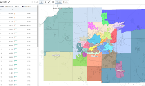
An open source web application that enables collaborative redistricting, including the ability to calculate metrics on-the-fly during the editing process and evaluate comparison to legal requirements.

An open source software toolkit based on Apache Spark that supports fast geospatial data processing by distributing tasks across computer clusters.

Open source platform that helps users find, combine, and analyze earth imagery at any scale, and share it on the web.

A guided app for city-based climate change adaptation planners that utilizes our Climate API.

An annotation tool designed for geospatial data, including satellite, aerial, and drone imagery. GroundWork supports object detection, chip classification and semantic segmentation projects, ideal for creating training datasets for machine learning projects.
Open Source
We believe that communities of knowledge, culture and innovation are more vital and energetic when outcomes are shared, enabling others to more effectively build on past work. As active members of a global software community, we think it is useful and important to share some of our knowledge and expertise by making contributions to open source and other community-based software efforts.
Check our GitHub for a list of tools and libraries, as well as our work on the GeoTrellis, OpenTreeMap, OpenDataPhilly, and DistrictBuilder projects. Many of our colleagues are active contributors to other open source projects too.
Featured Clients
Arts & Culture
- Philadelphia City Archives
- Boston Public Library Leventhal Map Center
- Greater Philadelphia Cultural Alliance
Education
- Open University
- Rutgers University
- Stanford University
- Temple University
- University of Pennsylvania
- University of Richmond
Elections & Politics
- Committee of Seventy
- MapLight.org
- Public Mapping Project
Health & Human Services
- DE Valley Assoc. for Education of Young Children
- Phila Corporation for the Aging
- U-Penn School of Medicine
- U-Penn School of Social Policy and Practice
- US Dept of Veteran Affairs
International
- Asian Development Bank
- Inter-American Development Bank
- UK Office of National Statistics
- World Bank
Natural Resources
- Philadelphia Water Dept
- Natural Lands Trust
- Pennsylvania Horticultural Society
- Stroud Water Research Center
- US Army Corps of Engineers
- US Dept of Agriculture