Skip to content
Azavea
  • What We Do
  • Research
  • About
  • Blog
  • Careers
  • Contact Us
Crop of map displaying data overlaid on Open Street Map.

Spatial Analysis

How Can OpenStreetMap be Used to Track UN Sustainable Development Goals?

By Eugene Chong on September 11th, 2020

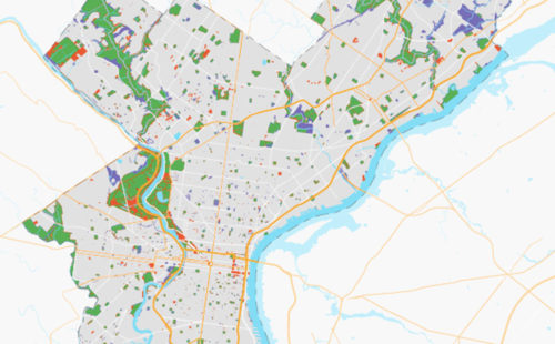
We learned that OpenStreetMap is a great source of data for tracking SDG indicator 11.7.1. OSM provides data on public open or green spaces in cities that is similar in quality to more “official” sources like municipal Open Data portals, and collecting the data from OSM requires relatively little effort.
Crop of map with data across the border wall between the U.S. and Mexico.

Spatial Analysis

Using GIS to Examine the U.S.-Mexico Border Wall’s Impact on Wildlife

By Evelyn Gorey on September 8th, 2020

Along with Defenders of Wildlife, we conducted an environmental impact analysis of the U.S.-Mexico border wall. We considered the spatial relationships between the existing and proposed border wall, regional at-risk wildlife, and the diverse habitats at the border in order to prioritize conservation efforts.
Crop of map showing data on a map.

Spatial Analysis

Choosing a Cell Size for Point Pattern Analysis: Gun Crimes in Baltimore

By Eugene Chong on September 4th, 2020

This analysis applies the Malleson methodology of choosing a spatial unit of analysis to gun crime data for the city of Baltimore. This methodology brings us a bit closer to understanding whether spatial variations in the crime data are picking up real signals or just noise.
Crop of map visualization that shows data for streets in Huntington Park, Philadelphia.

Spatial Analysis

Using GIS to Guide Philadelphia’s First Neighborhood-Level Forestry Plan

By Evelyn Gorey on September 3rd, 2020

The adoption of Philadelphia’s Urban Forest Strategic Plan and Hunting Park’s Forestry Plan presents a unique opportunity to address the need for equitable tree planting and the reduction of heat vulnerability, as these two plans are the city’s first cohesive attempts to prioritize and manage its urban forest.

Spatial Analysis

Housing & Landlords: Using Open Data to Find Substandard Conditions

By Fay Walker on September 26th, 2019

Using R and QGIS to analyze substandard housing in Philadelphia with open data. We used open data to identify violations, evictions, and illegal rentals.
Map highlight Native American areas that have been geocoded.

Spatial Analysis

Putting Native American Voters on the Map: Using Cadastral Data to Geocode Non-Traditional Addresses

By Fay Walker on September 12th, 2019

We used cadastral land survey data to geocode previously unmappable Native American voters in Montana.
  • 1
  • 2
  • 3
  • …
  • 7
  • Next
azavea-logo-white
990 Spring Garden,
5th Floor
Philadelphia, PA 19123
(215) 925-2600
Contact Us

Company

  • About
  • What We Do
  • Research
  • Careers
  • Blog
  • Press

Services

  • Software Engineering
  • Data Analytics
  • User Experience Design
  • Big Data Processing
  • Machine Learning
  • R&D

Newsletter

Stay in touch, spam-free. Sign up
Terms of Use • Privacy Policy • Directions
© 2023 Azavea