Skip to content
Azavea
  • What We Do
  • Research
  • About
  • Blog
  • Careers
  • Contact Us

Featured Posts

Software Engineering

Cloud Detection in Satellite Imagery

By James McClain on February 8th, 2021

Company

This Month We Learned — February 2021

By Casey Cesari and James Santucci on March 25th, 2021

  • All Categories
  • Company
  • Spatial Analysis
  • Events
  • Software Engineering
  • Design
congressional-districts

Spatial Analysis

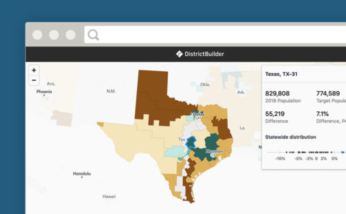
Which Congressional Districts are Over and Under Populated

By Daniel McGlone, Jeff Frankl and Luke McKinstry on July 29th, 2020

We calculated which congressional districts have become over or underpopulated since they were last drawn.
Screenshot of streets in the Curb LR Viewer.

Spatial Analysis

Maintaining Data on the Curb with CurbLR: A New Open Standard

By Ross Bernet and Simon Kassel on July 7th, 2020

CurbLR is a promising new open data specification for curb regulation. We used it to visualize and analyze Philadelphia's curb management approaches affect on traffic.
Screenshot of CovidCareMap app.

Spatial Analysis

How We Built a National Hospital Dataset for Coronavirus Relief

By Simon Kassel on June 9th, 2020

We pulled data from disparate hospital data sources to create a comprehensive national dataset of the hospital system for the COVID-19 response, using geocoding, proximity matching, and fuzzy string matching.
Calendar overlaid by outline of districts.

Spatial Analysis

What A Delay in the U.S. Census Means for Elections and Redistricting

By Daniel McGlone on April 30th, 2020

The census has asked to delay delivery of data. What will that mean for redistricting and elections?
Photo of California roads and mountain range in the background.

Spatial Analysis

Local Redistricting is Transforming California Cities

By Luke McKinstry on February 27th, 2020

Redistricting is happening across cities in California in an effort to make representation more equitable. View our map to see where this is happening and why.
Map showing the officials who left office in color-coded dots.

Spatial Analysis

U.S. Officials Who Left Office in 2019 and Why

By Niki LaGrone on February 20th, 2020

Who left office in 2019? Why? The Cicero Data team mapped the U.S. officials who left office before the end of their term in 2019.
  • Previous
  • 1
  • 2
  • 3
  • 4
  • …
  • 37
  • Next
azavea-logo-white
990 Spring Garden,
5th Floor
Philadelphia, PA 19123
(215) 925-2600
Contact Us

Company

  • About
  • What We Do
  • Research
  • Careers
  • Blog
  • Press

Services

  • Software Engineering
  • Data Analytics
  • User Experience Design
  • Big Data Processing
  • Machine Learning
  • R&D

Newsletter

Stay in touch, spam-free. Sign up
Terms of Use • Privacy Policy • Directions
© 2023 Azavea