
Looking for more on this topic? Want to find the most recent satellite imagery in 2021? Download our new white paper.
At Azavea, we help our clients use machine learning and satellite imagery to map places all over the world—we’ve trained AI to map everything from buildings, to bodies of water, to solar panels and crosswalks. But every project starts with the same question: based on what you care about in the imagery, what’s the newest, cheapest, and highest-resolution imagery we can find?
Today, we’re sharing our simple tool for triaging these requests along with plenty of links to help guide you to the right image for your needs! Here is a simple flowchart to find the right recent satellite imagery source for your project:
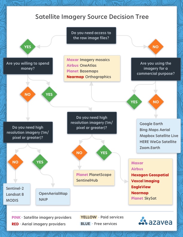
Free, browsable data
If you are just curious about seeing the most recent high-resolution image you can find for a given area of interest, and you don’t care about getting access to the raw images or using what you see for some commercial purpose, far-and-away the best tool you can use is Google Earth’s Explore New Satellite Imagery Tool. It’s a phenomenal way to visually check on recent imagery around the world and it even attributes the source of the imagery at every zoom level:

Google also has a neat project called Google Earth Timelapse, which allows you to see imagery of how the world has changed over the decades, which can be a lot of fun:

Some other great sources of non-commercial, non-downloadable imagery are:
Paid, browsable data
If you’re considering deriving a commercial product from the imagery you’re browsing (e.g. tracing building footprints or other cartographic features), you should consider a paid option that allows for derivative works to be produced. Google’s Maps API is notoriously stingy in this regard, with its terms of service even limiting your right to display content derived from Google imagery on a map that isn’t also provided by Google.
Rather than license imagery from Google that they’re, in turn, licensing from imagery providers, it usually makes more sense to go directly to the source. For high-resolution aerial imagery, NearMap orthographics provide great coverage in the U.S. and Australia and has a very simple user interface available through any web browser. For larger-area basemaps, satellite imagery providers make more sense:
[adinserter block = “2”]
Free, downloadable data
Here’s where things get interesting—we’ve written previously about the explosion of freely available, openly licensed, and constantly updating satellite imagery in our blog post, An Introduction to Satellite Imagery and Machine Learning. Three such data sources are:
- Sentinel-2 (the European Space Agency’s constellation of satellites imaging the entire landmass of the earth once every five days)
- Landsat 8 (the USGS’s satellite which images the earth once every 16 days)
- MODIS (NASA’s satellite constellation which images the earth every 1-2 days)
Data from all three of these satellite constellations can be downloaded for free from either Earth on AWS or Google’s Earth Engine Catalog. A warning: these are very large files and the imagery itself is lower resolution than what you might expect to see on a typical web map. Make sure you familiarize yourself with the data before downloading a lot of it!
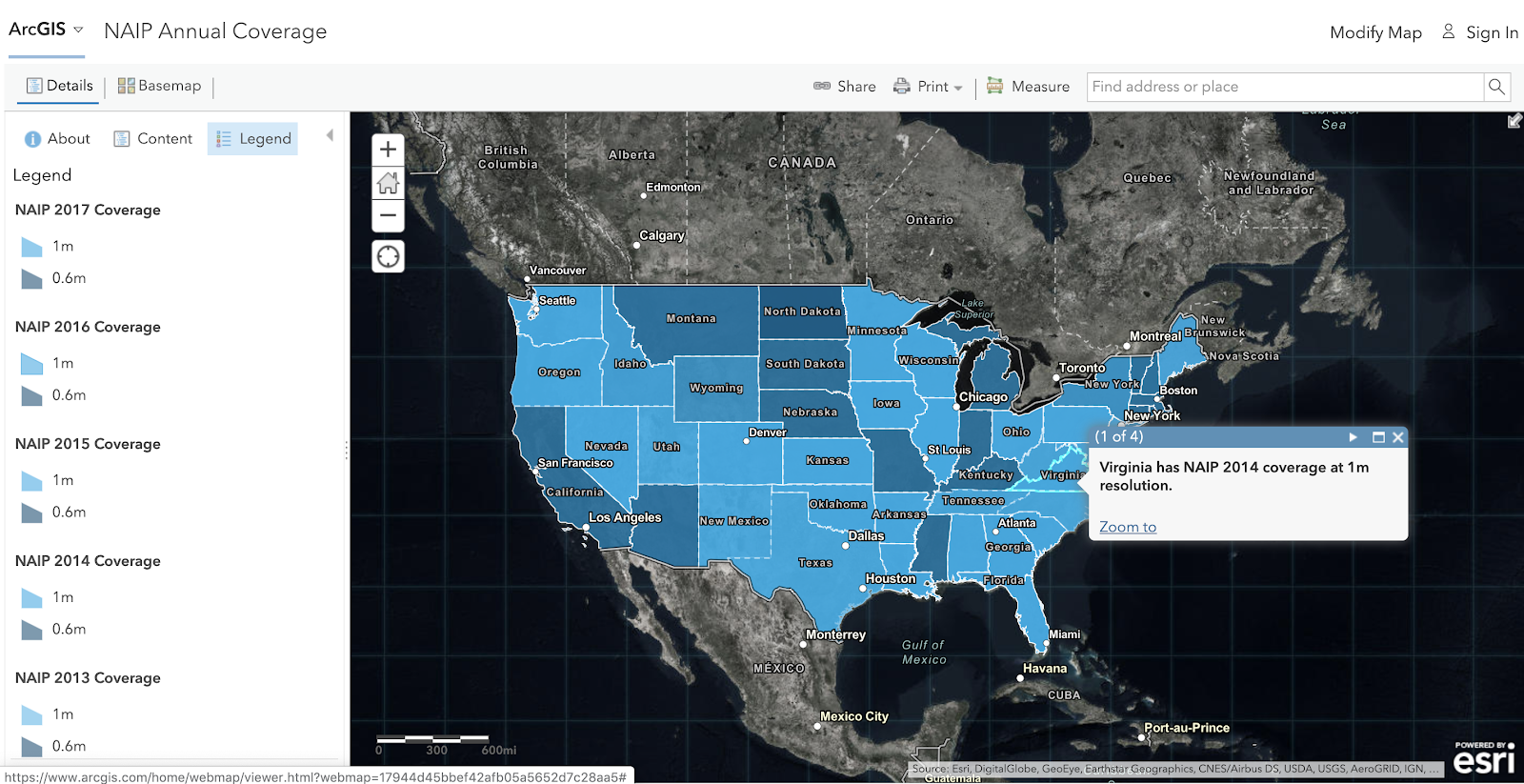
For high-resolution aerial imagery, your options are much more limited. In the U.S., the USDA’s National Agricultural Imagery Program (NAIP) captures 1m/pixel or better imagery for the entire contiguous United States once every other year. That imagery can also be downloaded from either Earth on AWS or the Earth Engine Catalog—you can also browse when the most recent imagery was collected for each state (and at what resolution) at this free online coverage map hosted by ESRI.
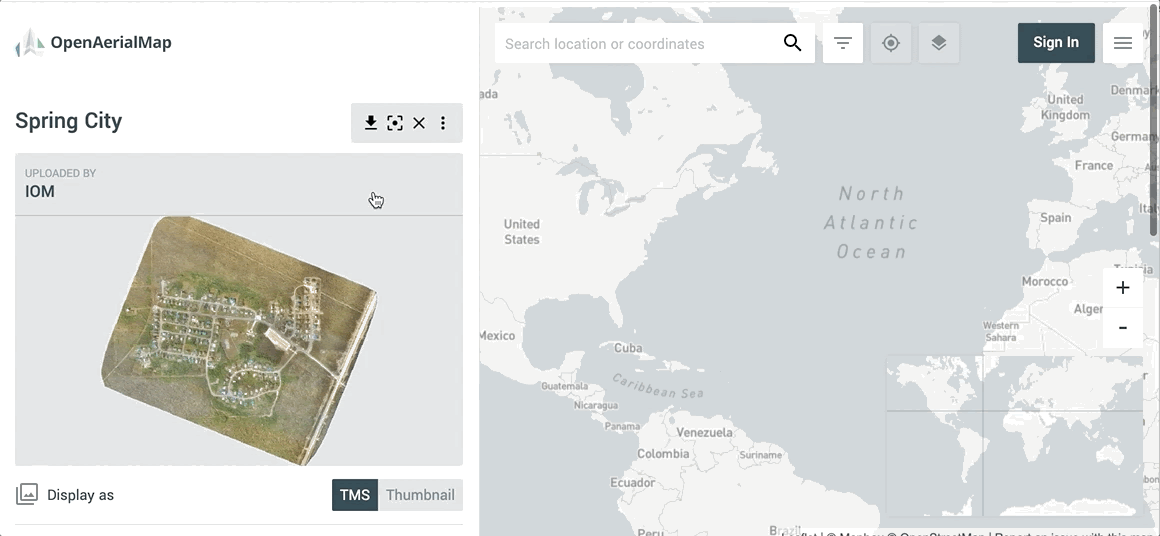
Outside of the U.S., the best option is the tremendous OpenAerialMap project, which allows users from all over the world to upload their own drone orthomosaics and has already accumulated over 10K such images.
Paid, downloadable data
Lastly, there’s the difficult case of needing high resolution, recently collected imagery (especially if you plan to derive commercial works from that imagery and need access to the raw files). We run into this situation quite frequently at Azavea, so we’ve gotten to know many of the providers over the years. If you’re new to this world, the first thing to know is that you’re almost certainly going to have to speak with a salesperson—there’s no such thing as simple, transparent pricing in the satellite and aerial imagery world (at least not yet).
For high-resolution satellite imagery:
For slightly lower resolution but higher frequency imagery:
For aerial imagery in the U.S. and Europe:
For aerial imagery in just the U.S:
A final note
There are plenty of other places to get access to some of the datasets I mentioned above—especially the free ones. Last time I checked, there were over 20 different browsers for looking at Landsat 8 imagery alone and that was more than three years ago! There are also plenty more aerial and satellite imagery providers—I simply listed some of the largest ones. If you decide you’re going to pay for imagery, do your own homework; some of the best deals you find are from independent pilots who will fly aerial or drone imagery for you on an hourly basis!
Regardless of what piqued your interest in finding up-to-date satellite imagery in the first place… I hope you find what you’re looking for.