
Co-authored by Joey James of Downstream Strategies
Downstream Strategies, an environmental and economic development firm, has worked extensively with Morgantown Utility Board (MUB) in Morgantown, West Virginia on source water protection planning since 2014. As part of the ongoing support for MUB’s Source Water Protection Program, Downstream Strategies, in partnership with Azavea, created a customized decision-support tool to assist MUB’s spill response efforts. The development of a comprehensive GIS-based tool, known as the MUB Monitor, launched in 2016 and was designed to help MUB managers track spills, assess upstream threats within the watershed, and make informed decisions.
Need for source water protection
EPA records indicate that from 2007 to 2016, there were 9,416 reports of Clean Water Act-defined Hazardous Substance discharges, and “3,140 reports that were reported to have reached water.” That means a lot of toxic chemical pollution of America’s lakes, streams, and drinking water sources, placing many people and communities at risk.
In 2014, a chemical spill in Charleston, West Virginia highlighted the need for comprehensive source water protection in the state. As the water provider to West Virginia University (WVU) and the state’s third largest city, MUB led efforts to prevent a similar crisis in the Upper Monongahela watershed. A joint effort between Downstream Strategies and Azavea resulted in the development of the MUB Monitor as a tool to help MUB track and respond to upstream threats that could jeopardize its source water quality.
Downstream Strategies was contracted by the MUB to perform technical services to expand, improve, and conduct an ongoing source water protection program, including an update and expansion of MUB’s Source Water Protection Plan (SWPP). Downstream Strategies, with Azavea, developed and implemented a web-based tool for mapping and analysis of the collected data.
MUB Monitor
Azavea’s technology and professional services team developed a system with features requested by Downstream and MUB. Azavea worked with Downstream to determine the exact requirements of the spatial database, both for this and potential future applications, and developed a schema that supports the types of queries required by the application:
- A web-based tool for the mapping and analysis of large amounts of spatial data to evaluate threats, locate hot spots, prioritize response efforts, and develop response strategies
- Works on the latest two versions of Microsoft Internet Explorer, Google Chrome, and Apple Safari browsers
- Allows secure access to data via workstations, laptops, handheld devices that support web browsing
- Generates maps for use in reports and during incident response
- Can be easily updated
- Can be used for planning drills and exercises
- Provides a powerful query and data presentation tool, allowing multiple agencies to use the same information for emergency response planning
According to Evan Hansen, president of Downstream Strategies,
“West Virginia water utilities have made great strides since the 2014 water crisis to reduce risks of drinking water contamination. But the MUB Monitor is the only system being used by water utilities in the state to identify and manage the highest threats and to respond to spills.”
Spill response
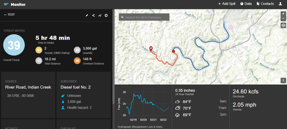
The MUB Monitor is designed to track spills occurring upstream of MUB’s drinking water intake on the Monongahela River. Using this tool, MUB managers can enter information about a spill, including the location, substance, and amount spilled. Once entered, the Monitor calculates the estimated travel time and tracks the spill as it flows downstream towards MUB’s intake. Azavea’s extensive experience with the development of geoprocessing tasks proved extremely valuable. Our experience with calculating upstream and downstream networks with the USGS National Hydrography Dataset and other customized datasets allowed for quick and accurate work.
Threat matrix
The threat matrix assigns risk from aboveground storage tanks and spills based on toxicity, proximity to the nearest stream, travel distance to MUB’s intake, and the volume spilled.
If the location of a spill is known, that location is entered on the map by coordinates, address, by selecting from a list of sites, or by selecting an area on the map. Based on the threat matrix developed, a user with the proper permissions is able to add a contaminant type, quantity, and time of the spill. A response strategy is then created, including the relative severity of the threat and estimated travel times to intake locations. This results in information, based on analysis performed by end users, including response options, operational and procedural protocols, maps, and other information about the spilled material.
If a spill is discovered from an unknown source, the system provides guidance to attempt to identify potential sources. A user interface allows users to input spill characteristics, and data prepared by end users is accessed to identify upstream facilities that are known to store contaminants with those descriptions. Additionally, other potential sources, such as bridges, railroads, and highways near waterways are identified.
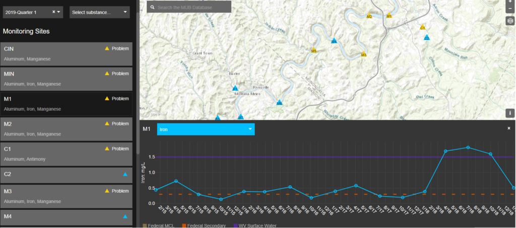
Data management
The MUB Monitor stores thousands of potential contaminant sources within the watershed. It allows users to map, list, query, analyze, and prioritize threats. Water quality sampling data, both from real-time instruments (SCADA system integration: real-time source water data) and other prepared sources of data are available on the map.
Communications
The MUB Monitor is integrated with MUB’s contingency and communications plan. It includes a database with spill response contacts from relevant agencies, media, and other organizations. The nature of this application lends itself to mobile use by data gatherers and emergency response personnel in the field, and as such its use on mobile devices will be especially important.
The work goes on
The MUB Monitor system is a valuable tool to help MUB staff assess and respond to upstream threats.
Downstream has worked with MUB to complete MUB’s 2016 Source Water Protection Plan (SWPP) and 2018 SWPP update. Widely regarded as the model SWPP in West Virginia, this plan is designed to minimize the risk of contamination of MUB’s source water and to prepare MUB to immediately react to contamination events.
Our ongoing activities include watershed monitoring, windshield surveys, aerial reviews, review of publicly accessible permit materials, facility and aboveground storage tank inspection report reviews,
The collaboration between Downstream Strategies and Azavea resulted in a comprehensive system to monitor, protect, and respond to water threats that impact people, resources, and wildlife. These efforts also support global efforts, like the UN SDG 6, to ensure access to water and sanitation for all.
Azavea will be attending and exhibiting at the upcoming American Water Works Association ACE19 Conference in Denver. Let us know if you’ll be attending and drop by booth 740 to learn more about this and other developments, projects for water, and stormwater solutions.