
Azavea is pursuing the development of a free-and-open-source pipeline for mass conversion of OpenStreetMap data to Mapbox VectorTiles. The project is called VectorPipe and is based on GeoTrellis, a Scala library also developed by Azavea.
This post outlines our general approach, our current status, and some of the roadbumps we’ve hit along the way.
The Six-fold Path
OSM Planet data is freely available in two formats: XML and Protobuf. Many 3rd-party sites offer subsets of this data, locked to specific areas (countries / cities), but we have our sights set on the entire block. The sizes of the files might at first seem prohibitive: 55gb for XML, and 34gb for Protobuf. Furthermore, we’d want to parse the dataset in parallel with Apache Spark for easy marshalling into GeoTrellis types. After an initial foray into splitting the XML data for subsequent parallel parsing, we abandoned this approach for another that favours ORC files, which are designed to be read in parallel from the start.
In converting the source data into a usable set of VectorTiles, we identified six key steps:
- Convert the OSM Protobuf data into an ORC file
- A tool already exists for this, and we are collaborating with the author to improve it.
- Parse an RDD[Element] from the ORC
- Critically, an ORC file can be queried in parallel via Spark SQL, the results of which are not hard to marshal to Scala classes.
- Convert the
Elements to GeoTrellisFeatures- Lots of “
RDDalgebra”, as I’ve begun calling it
- Lots of “
Luckily Step 1 was “done for us”. Code from step 3 is being tested, and step 6 was already possible with our VectorTile codec implementation. Step 4 is in progress as this post is being written, while 2 and 5 are pending.
In terms of the actual pipeline code, assuming an ORC file to have been produced via Step 1, the rest is envisioned simply as:
import org.apache.spark.sql._
import org.apache.spark.sql.hive._
import vectorpipe.osm._

/* Visible in any application using Spark */
implicit val sc: SparkContext = ...

/* For reading the ORC file via Spark SQL */
implicit val hc: HiveContext = ...

/* How should a SpatialKey map to a filepath on S3? */
val s3PathFromKey: SpatialKey => String = SaveToS3.spatialKeyToPath(
  LayerId("sample", 1),
  "s3://some-bucket/catalog/{name}/{z}/{x}/{y}.mvt"
)

/* Filepath to the ORC file */
val orc: String = ...

/* The work */
Orc.readFrom(orc)                                                 // RDD[Row]
  .map(r => Element.parseFile(r))                                 // RDD[Element]
  .toFeatures                                                     // RDD[Feature]
  .toGrid                                                         // RDD[(SpatialKey, Seq[Feature])]
  .mapWithKey({ case (k, fs) => VectorTile.fromFeatures(k, fs) }) // RDD[(SpatialKey, VectorTile)]
  .mapValues(_.toBytes)                                           // RDD[(SpatialKey, Array[Byte])]
  .saveToS3(s3PathFromKey)                                        // Unit
OpenStreetMap Data
This section acts as a primer and can be skipped if you know how OSM categorises their data. We’ll be referencing the XML form of the data here for demonstration purposes only.
OpenStreetMap has three primitives, collectively known as Elements. All Elements have common attributes, and can contain further metadata in <tag>s.
Node- Any discrete location on earth, or a “node” in a Way
- Translates easily to a GeoTrellis
Pointif not part of a Way
Way- Some line-like object on the earth, like a road
- If a Way is “closed”, it translates nicely to a GeoTrellis
Polygonand could represent a building - If “open”, it becomes a
Lineif also not part of a “Geometric Relation”
Relation- Any abstract grouping of Elements
- Each Relation has a
typetag, which can be set to anything - Some common types are geometric – like
multipolygonorboundary– but these aren’t set in stone - Multipolygon Relations have agreed-upon semantics for combining many Ways to form large Polygonal structures, like enclaves and exclaves between countries
- Relations can refer to other Relations, forming Relation Graphs
- Relations store metadata relavent to the entire structure
Visual examples:
<node id="300006332" visible="true" version="2" changeset="11137522" timestamp="2012-03-29T12:06:03Z" user="Divjo" uid="63375" lat="24.3102749" lon="68.8355605"/>

<way id="19551824" visible="true" version="1" changeset="512823" timestamp="2008-01-02T12:20:13Z" user="dmgroom_coastlines" uid="4772">
  <nd ref="202991342"/>
  <nd ref="202993872"/>
  <nd ref="202993694"/>
  <nd ref="202993703"/>
  ...
  <tag k="admin_level" v="2"/>
  <tag k="border_type" v="nation"/>
  <tag k="boundary" v="administrative"/>
  ...
</way>

<relation id="549971" visible="true" version="2" changeset="4379439" timestamp="2010-04-10T05:58:16Z" user="Marcott" uid="173927">
  <member type="way" ref="54928207" role="outer"/>
  <member type="way" ref="54928404" role="inner"/>
  <tag k="type" v="multipolygon"/>
</relation>
Reading Data from ORC
By adding a dependency, Spark code gains the ability to query ORC files via SparkSQL. This discovery was a big relief, as it presents itself as an elegant solution to a problem we were approaching with custom code. Reading and marshalling to Scala classes is as easy as:
/* The type to marshal to */
case class Node(id: Long, tags: Map[String, String], lat: BigDecimal, lon: BigDecimal)

implicit val hc: HiveContext = ...

/* A lazy reader */
val data = hc.read.format("orc").load("VA.orc")

val nodes: RDD[Node] =
  data
    .select("id", "tags", "lat", "lon")
    .where("type = 'node'")
    .as[Node]
    .rdd
Here is a fuller example.
There is much more work to be done in this area, but this is a good start. Once employed, it gives us a full RDD[Element] from ORC data, which we can convert to GeoTrellis types for further processing.
Conversion to GeoTrellis Features
Relations
Here be dragons, and Relations birthed them hence. Recall that:
- Each Relation has a
typetag, which can be set to anything - Relations store metadata relevant to the entire structure
- Relations can refer to other Relations, forming Relation Graphs
(1) means that we (the GeoTrellis team) have to draw a line in the sand for which Relations we need to give special treatmeat when converting from Element to Feature. Geometric Relations like multipolygon and boundary are obvious, but further out than that and the answer isn’t so clear.
One example of a “non-geometric Relation” would be a bus route, composed of many Nodes and Ways. Each single Node could be a busstop or bus depot, while the Ways show the actual route. In an actual display of a VectorTile containing this bus route, it would be good to see each busstop on the map, and also be able to confirm (via mouse-over metadata display, etc.) that any given node is in fact a stop. The Nodes themselves (in the OSM DB or XML form) have no idea they’re part of a route. In fact, one stop could be a member of multiple routes, and thus multiple Relations. Relations know who they contain, but not the other way around. This is where (2) comes in. Relations store the structure-wide metadata, but for the final Node to know about it, the Relation’s metadata has to be disseminated across its members.
And how hard could that be? Well, recall (3). What if your bus route is itself pointed to by a higher Relation? Now we have Relation Graphs to deal with. After consulting with OSM contributors in their IRC, the concensus is that while these Relations should form Tree structures, there’s no guarantee that they will because of the permissive way their data-type relationships are defined (i.e. Relations can refer to anything). There’s also no guarantee that the Graphs found won’t be cyclic.
Our answer is to apply Graph theory and force a Tree structure, essentially declaring Relation Graphs to be illegal. We ported an established Graph implementation to Scala and gave it the operation:
topologicalForest[K, V]: Graph[K, V] => Forest[V]where type Forest[T] = Seq[Tree[T]].
This gives us a sensible method for interating across Relations and disseminating their metadata to their children.
Conversion Quirks
Polygons can be formed in three ways:
- From a single “closed” Way
- From a
multipolygonRelation that designates which Ways to stitch together - From a combination of the above two, forming holed Polygons
Here is a real example we can analyse. The gray-black areas/lines are our converted data laid over the original OSM map.
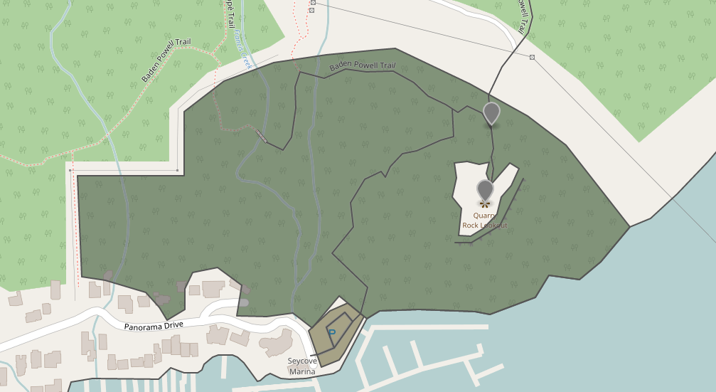
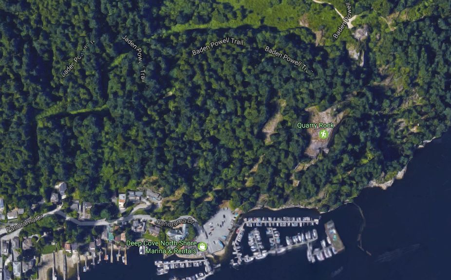
Here, the bottom-most shape (containing the blue P) is a single, closed Way. Above it is a two-Way multipolygon representing a forest with a large rock to one side. The other black lines snaking about are single Ways. Here is the same shot from Google Maps for context:
Quarry Rock itself is represented in OSM as a hole in the forest around it. This is a pretty normal holed Polygon. We’ve seen the XML for this Relation already, in the XML examples above. Interestingly, the bounding box which produced all this was smaller than you might expect:
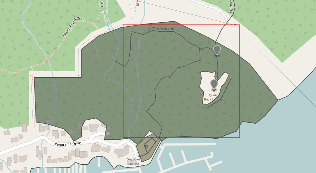
This is due to how OpenStreetMap’s “Export” utility works. The rough algorithm is:
- Find all Nodes within the bounding box
- Find all Ways which reference those Nodes
- If not all Nodes referenced by a Way in this bbox are present, grab them anyway (non-recursively, this won’t go out and find yet more Ways based on the new Nodes).
- Find all Relations which reference those Nodes and Ways
- Unlike Ways, even if a Relation refers to other Elements outside the bbox, don’t fetch them. This prevents a flood of long Ways outside the bbox from being added by mistake, producing large XML.
So the full forest Polygon we see here is because of rule (2). What happens if we grab the XML for a smaller bounding box?
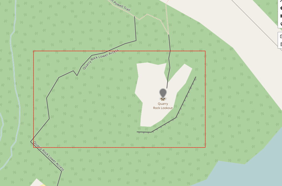
Hm, no Polygon present that represents the Rock. Checking the XML, the Way for the Rock and the Relation for the whole forest were fetched, but critically the outer Way for the forest edge was not. In this case, our algorithm abandons the attempt to make the holed Polygon.
A similar thing can happen to stray Ways which ought to be stitched together, but can’t be due to the caveat in (3) above. This was a source of strange Exceptions for a while. For now we abandon such Ways, knowing that they would be properly fused if using the full data set.
Current Work
I personally am continuing work at Step 4, predicting a move to Step 5 sometime next week. With the finalization of Step 2, we can at last begin producing VectorTiles to gauge performance and start some preliminary analysis. We’re excited for what this project will mean for both Azavea and the greater GIS community, so stay tuned.