
In response to a request from an OpenDataPhilly user, Azavea compiled historic political ward and ward division data from different sources and published it to the OpenDataPhilly portal. Updated political ward and ward division files can be downloaded as shapefiles here.
Background
OpenDataPhilly is a portal that provides access to more than 300 data sets, applications, and APIs related to the Philadelphia region. Our team at Azavea built the portal in 2011, based on the idea that providing free and easy access to data information encourages better and more transparent government and more engaged and knowledgeable citizens.
Users can search for and locate both municipal and non-municipal data data sets based on keyword and category searches. We included information about the origins, update frequency, and other details for each data set, application, or API. The record for each data source also includes links for downloading the data or accessing the application or API.
Participating in Open Data
In addition to searching for data sets, the public can get get involved in the process of data management by following the OpenDataPhilly mailing list. Whenever possible, we respond to requests for data – we help to connect users with data sources or compile the data ourselves and publish it to OpenDataPhilly.
We received a request for information about political ward and division maps via the mailing list earlier this year:
Hello,
I’m looking for prior year political ward and division maps similar to the one on opendata already (https://www.opendataphilly.org/dataset/political-ward-divisions).
Are there other geojson files going back to 2003? Or is there a description of the changes that have been made since then?
Thanks!
Gathering & Cleaning Data
Robert Cheetham, President and CEO of Azavea, was able to track down CDs including political ward data from his time working at the Philadelphia Police Department, at the City of Philadelphia, and early days of Azavea. We also gathered historic ward and ward division boundary data from PASDA, who had the only online source for archived data sets.
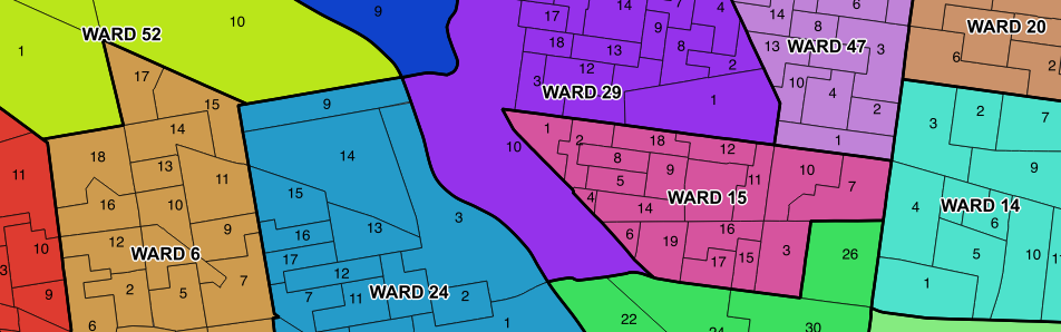
Each political ward includes multiple political ward divisions within it’s boundary. In some cases, the ward division boundaries were available, but political ward files did not exist. We dissolved the ward division polygons based on the “WARD” field to create political ward polygon files.
Some of the original attribute tables included unique ID values based on ward and division, while others used an object ID as the unique value. We used an expression in QGIS to concatenate the ward numbers and ward division numbers into a string field.
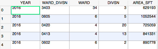
This string is unique to each polygon and the 4-digit format of the string is standard for all years. It was important to take the time to clean the data so that users have a clear comparison of the data between iterations.
Data Location
The historic ward and ward division data is posted on OpenDataPhilly and the Azavea GitHub geo data repo.
The following table breaks down the files by year. Note that ward division files were not available for the year 2003.
| Historic Ward & Ward Division Data | ||
| Year | Wards | Ward Divisions |
| 2003 | X | Not Found |
| 2005 | X | X |
| 2008 | X | X |
| 2009 | X | X |
| 2010 | X | X |
| 2011 | X | X |
| 2012 | X | X |
| 2013 | X | X |
| 2016 | X | X |
Reflections on Open Data
Releasing data to the public creates an atmosphere of transparency and can help to hold organizations accountable. While posting data is an important step in the Open Data process, it is only one step. The ward and ward division boundary data, like other GIS data, have been available as open data for more than 10 years, but only the most current version is generally available.
There are some data sets on OpenDataPhilly that are released as continuously updated data, including the L&I permits/violations API and Police Department crime data sets. Further, a few others are released as multi-year data sets, for example many of those released by the School District of Philadelphia are available for multiple years. But most open data sets, particularly those from GIS databases, are only available as the current version. That is likely sufficient for most applications, but there will be many situations in which we really need the historic data. Historic election results are one such situation, but real estate data and many others would have similar utility if they were made available as multiple snapshots.
How can we better handle changing data sets over time? Post your ideas in the mailing list to keep our conversations open as well.