
As organizations across the United States and around the world work with OpenTreeMap, we’re thrilled to see the tree count climb higher on each map. From a map with a few hundred trees to TreeMapLA’s nearly half a million trees, each map demonstrates the important role the urban forest plays in creating healthy and vibrant communities.
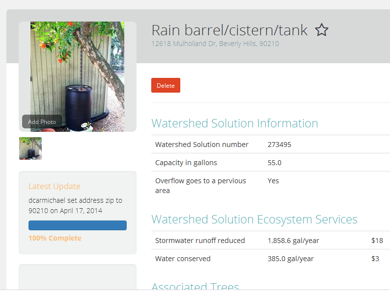
We know, however, that trees are just one part of the larger story of urban sustainability. As climates change and regions face severe heat, drought, and weather events, more organizations are promoting innovative techniques to harvest rainwater, prevent stormwater runoff, and conserve water whenever possible. To assist those organizations, we’ve expanded OpenTreeMap to support tracking resources such as bioswales, rain gardens, and rain barrels using our new Green Infrastructure module.
Based in Brooklyn, the Gowanus Canal Conservancy is one of the first groups to use the new green infrastructure tracking on OpenTreeMap. The Gowanus Canal Conservancy focuses on providing stewardship for the Gowanus Canal watershed including tracking trees in the area and installing bioswales to assist with stormwater management.
The Conservancy is particularly interested in gathering information on the existing bioswales including the plants or trees found in the bioswale and also noting the stewardship activities completed by local residents and volunteers. Removing litter, pruning plants, aerating soil, and other stewardship activities assist in keeping the bioswale functional, healthy, and able to effectively manage stormwater on site. The Gowanus Canal Conservancy hopes to use the green infrastructure features in OpenTreeMap to direct future volunteer stewardship activities and encourage interest in the bioswales and other sustainability initiatives.
In addition to bioswales, OpenTreeMap also supports tracking rain gardens and rain barrels as well as customizing each of these three types of features by adding data fields, stewardship activities, comments, and photos. We hope to expand green infrastructure tracking in the future to include additional resource types such as green roofs and support calculating the environmental and economic benefits of the various resources.
The Green Infrastructure module is part of a recent update to the OpenTreeMap subscription pricing. OpenTreeMap is now available for a lower monthly fee that includes most major features and the ability to map up to 25,000 trees. Additional trees and separate Customization and Green Infrastructure modules can be purchased as your tree map grows to meet the needs of your projects. More information about green infrastructure tracking can also be found in the recording of our most recent OpenTreeMap webinar.
Featured Image: @GowanusGreen