
On February 25, TreePeople, an environmental nonprofit dedicated to promoting the power of trees, people, and nature-based solutions, launched TreeMapLA, the newest member of the OpenTreeMap family.
Covering all of Los Angeles County, TreeMapLA enables residents to add and edit information about trees, search existing tree records, upload images, and view the environmental and economic benefits generated by the trees. The goal is to create a tool that can help organizations and individuals learn about the existing urban forest and plan future activities. Check out the TreePeople blog for an excellent overview of the project.
The work with TreePeople has resulted in not only the creation of TreeMapLA but also some helpful new features in the OpenTreeMap product to support mapping rainwater harvesting activities such as rain barrels, rain gardens, or reductions in areas covered by turf or concrete. Before TreeMapLA, OpenTreeMap had focused solely on trees. However, trees often are just one part of the larger story of the urban environment, especially in areas with water shortages or locations with combined sewer infrastructure.
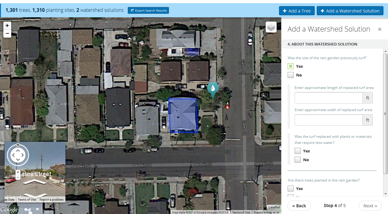
TreePeople was interested in having a new“Add a Watershed Solution” feature that would provide TreeMapLA users with the ability to map and add information about three types of rainwater harvesting techniques. Users identify the type of solution (rain barrel, rain garden, or turf/concrete reduction), the location of the watershed solution, the nearby roof from which water drains into the solution, and the answers to a few questions about the specific watershed solution.
With just a few clicks, users can map a rain barrel and view the stormwater runoff reduced by the rain barrel as well as the water conserved by using water stored in the rain barrel. We built this new rainwater harvesting feature in such a way that it can be expanded to track other types of natural resources in the future and think there could be great potential for capturing information on a broad range of green infrastructure.
TreeMapLA is an implementation of the new OpenTreeMap Cloud system and looks a bit different from other OpenTreeMap sites like PhillyTreeMap and the Urban Forest Map. As part of OpenTreeMap Cloud, the map will be regularly updated with new features as they are added to the OpenTreeMap platform over the next few months. Other new features in the works include searching for trees based on needed stewardship activities like watering or open alerts indicating some type of maintenance is required. In the past few months, we have been releasing a new version of the software every two weeks, and we are excited about the new work in the pipeline for the next several months.
Visitors to TreeMapLA mapped over 1,000 trees in the first few weeks after the system was available, and more trees show up on the map every day. You can check out TreeMapLA at www.treemapla.org and explore the many environmental resources in Los Angeles County!
Interested in starting your own tree map at a click of a button? Visit opentreemap.org to sign up for a one-month free subscription.