
After a sweltering summer, fall is finally in the air here in Philadelphia, and that can only mean one thing: a transit hackathon is in the works! For the third year running, our friends and Code for Philly stewards over at Philly web development shop Jarv.us are organizing a transit and transportation themed hackathon this weekend: Apps for Philly Transit! While in the past two years the event was known as Apps for SEPTA, this year a bunch of us – including Jarv.us’ Chris Alfano, Philly CDO Mark Headd, SEPTA’s Mike Zaleski, Robert and I at Azavea, and others in the Philly civic tech community – hatched a plan to broaden the scope of this venerable hackathon to include not just SEPTA, but transit and transportation related agencies across the region. We’ve received an impressive response, with several individuals and organizations stepping forward to attend the event and provide expertise, support, and that most crucial of resources, open data!
- Bicycle Coalition of Philadelphia
- Philadelphia International Airport
- Philadelphia Parking Authority
- Center City District
- Delaware Valley Regional Planning Commission
- Uber – giving a prize and credits to all new users
- and of course, SEPTA!
I’ve personally been working with Lauren Gilchrist at Center City District and Chris Pollard at DVRPC over the past week, who have both been enthusiastic about sharing and opening some brand new datasets from their organizations. Sources tell me that there may be exciting announcements from PHL Airport and the PPA at the event as well – but we’ll just have to wait a few hours more to see!
Azavea is making a big release at the hackathon this weekend, too. We used the timing of Apps for Philly Transit to kickstart development of some new features for our open-source GeoTrellis geodata-processing framework – namely, travelshed calculations. With support from the William Penn Foundation and TechImpact, we’ve taken a lot of the concepts from our Commonspace.us app that we built a few years ago, and built them into the open-source GeoTrellis Transit project. We’ll be hosting and maintaining a free version of the Geotrellis Transit API for the Philadelphia region at http://transit.geotrellis.com/, and GeoTrellis developers Josh Marcus and Rob Emanuele will be present at the Apps for Philly Transit hackathon (as well as yours truly) to help teams that want to use it in their projects.
Travelsheds?
So what can you do with GeoTrellis Transit? In two words, “calculate travelsheds.” OK, great…but what’s a travelshed?
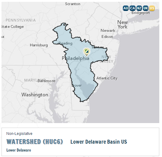
First let’s think of the concept of a “watershed,” which the EPA neatly defines for us as:
A watershed is the area of land where all of the water that is under it or drains off of it goes into the same place.
Using the live demo of the Cicero API, you can actually determine the watersheds that Azavea’s office in Philadelphia lies in. There are several different types, large and small with different criteria, but one key feature of most is the Delaware River, the largest river in our area that makes the border of Pennsylvania and New Jersey. All of the streams, tributaries, and ecosystems in the “Lower Delaware Basin” watershed area (where we are) eventually meet up with or flow into or are affected by the lower Delaware River, and make up the same watershed.
Applying the same concept to travel and travel patterns brings us the idea of a travelshed. Unlike water, whose travel is pretty much constrained by the Earth’s topography, as travelling humans we have some control over the area in which we are able to travel (our “travelshed”) by allowing ourselves more or less time to reach a destination (do I want to travel 10 minutes to the corner store, or give myself 20 minutes to get to the mall with greater selection?) and/or using a variety of transportation methods (walking, bicycling, public transit busses, trains, or private cars) that allow us to travel shorter or longer distances over the same amount of time. However, similar to water, our travel patterns are constrained to existing roads, sidewalks, transit tracks and lines, and barriers like the Delaware River (over which there are only a few bridges at key points!).
Asking Transit Questions
GeoTrellis Transit was designed to take all these factors into consideration and help answer questions like:
- Given a starting location and a method of travel (walking, biking, public transit), how far can I travel in a given amount of time?
- Show me a map that shows how long it takes to arrive at a particular location from everywhere in the city.
- Given a list of destinations, which of these destinations can I reach from my start location, and in how long?
- If I am leaving somewhere now and want to be home in two hours, where could I stop in the middle and for how long? (We call this the “Scenic Route” service.)
To answer these questions, GeoTrellis Transit leverages a street and road network based on data from OpenStreetMap, GTFS data from SEPTA, and the powerful geoprocessing capabilities of the core GeoTrellis library to analyze all that data and return travelshed analysis results within seconds to your browser. The API will return raw raster and vector data on travelsheds that you can use in a traditional GIS, or WMS images you can embed in a web map in a browser application.
See it in Action!
In the demo above, we’ve given ourselves a starting location in the southeast part of Philadelphia’s Northern Liberties neighborhood. Let’s say it’s a sunny afternoon and we have plenty of time for urban exploring – so we’ll give ourselves 60 minutes travel time to go somewhere interesting. And we don’t have our bikes with us (so we’re walking on our own two feet), but we do have a few of the last remaining tokens for SEPTA busses and subways in our pockets. Looking at the map above, two things are immediately evident about our travelshed:
- The only place to cross the Delaware River as a pedestrian is the Ben Franklin Bridge. Walking it expends a lot of our 60 minutes, so once we’re in Camden, we can’t walk very much farther with our alloted time.
- Northern Liberties has a few stops on the Market-Frankford Line subway, which travels out towards West Philly and up towards Northeast Philadelphia, really fast. That’s why the areas directly on the MFL are bright green or even orange, signifying in our color ramp that those areas can be reached much more quickly than the areas in the blues.
What travel questions will you use the GeoTrellis Transit API to answer? Join us at the Apps for Philly Transit hackathon this weekend!