
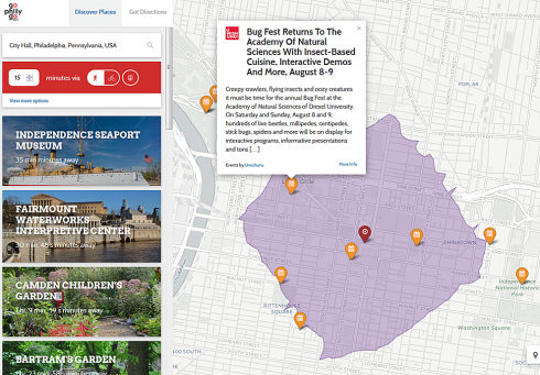
There’s a new way to explore the Greater Philadelphia region when you don’t have a car! On June 30th, the Clean Air Council launched GoPhillyGo.org. Visitors to the website can plan trips, discover events, explore featured locations, and check bike share stations according to their current location and how much time they want to travel. The multi-modal trip planner shows how to get around the Greater Philadelphia region via transit, bicycle, walking, or a combination of modes. Users can discover featured locations, such as parks and museums, as well as upcoming events on the map based on their location, travel time and mode of sustainable transportation.
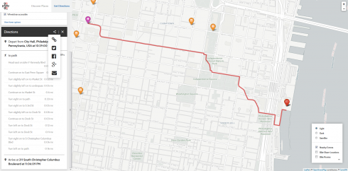
GoPhillyGo utilizes travelsheds, or areas on a map that outline how far the user can travel in a given amount of time, via a given mode or modes of travel. This provides an easy way to see, for example, which upcoming events on the map are within a twenty minute walk from home, or which areas might be more accessible by transit or by bicycle. Users can select potential destinations or events to learn more information from sites like Uwishunu, the official tourism blog of Philadelphia. Users can then further customize their travel plans by setting a preference for flatter, safer, or faster bicycle routes, changing the maximum distance they are willing to walk to and from transit stops, or wheelchair accessibility. Once a user selects a trip, they can share simplified directions lists via email, Twitter, Facebook, Google+, or through the link. If the trip involves bicycle and public transit, the directions will include links to the bicycle policies of the relevant transit agencies.
Users can customize and share their travel plans.
GoPhillyGo combines many different open source software projects with public data to provide these services. Directions and travelsheds for the site are powered through an open source platform called OpenTripPlanner, while information about the road network comes from OpenStreetMap, a community curated world map. OpenStreetMap provides OpenTripPlanner with street data, such as whether a road is one way, which streets have bike lanes, and whether a bridge has pedestrian access. Information about transit schedules comes from official General Transit Feed Specification (GTFS) data published by SEPTA, NJ TRANSIT, and DART, as well as a PATCO GTFS project maintained by one of the developers of GoPhillyGo, using data from the schedule PDF on the PATCO website. Bicycle lanes and Indego bike share station status information come from data published by the City of Philadelphia. The regional bike trails network comes from data published by the Delaware Valley Regional Planning Commission.
GoPhillyGo helps people explore and navigate the Greater Philadelphia region through the use of public data and open source software projects. The website encourages travel by alternate modes to passenger vehicles, and enables adventures of learning and discovery. Make sure you use it next time you are in Philly!